New Bridleway in Slaugham

What a lovely Christmas present for local riders in the Warninglid/Slaugham/Handcross area!

Slaugham bridle way 11.6.15

The new bridleway between Nursery Lane and Staplefield Road, Slaugham was opened for use on 20th December 2014. It links well ridden lanes and, in this particularly wet spell of weather, enables that rarity, safe riding that is also dry underfoot!

One can now ride a route from the Warninglid flyover to Slaugham Village, something not possible since the A23 was safe enough to ride!


The surfacing of the new horse margin alongside the northbound Handcross slip road has also been done, giving riders a safe link between bridleway Slaugham 7(Park Road) and the B2110 (Horsham Road) at Handcross.

(The HA will be doing a few minor improvements here before they are completely happy. This includes filling in a low area at the southern end of Slaugham 7, getting the utilities company to fix a damaged inspection cover and topping up the track surface at the B2110 end where there is currently a slight step.Slaugham 7 sliproad path


HAPPY NEW YEAR  and good riding!

Posted in News | Leave a comment

The Burgess Hill Northern Arc Developments (draft plan)

THE BURGESS HILL NORTHERN ARC DEVELOPMENT QUESTIONNAIRE


The Burgess Hill Northern Arc Developments (draft plan) are looking to extend the Green Circle at Burgess Hill to the north of the A2300 to Bedelands Park for walkers and cyclists. We need these new right of ways to include horse riders too, as at the moment they have been omitted.

You can access the questionnaire at www.surveymonkey.com/s/northarc (not available 09.7.15) and fill in the comments box with your views. Copy of consultation boards can be at found at www.nexusplanning.co.uk/news

Consultants are Nexus Planning,

Suite A, 3, Weybridge Business Park,

Addlestone, Weybridge, Surrey, TK15 2BW

Posted in News | Leave a comment

Downs Link at Bramber – New, Safe, Road Crossing

 An additional route for the Downs Link crossing of the A283 at Bramber is to be provided. The fast traffic and poor sightlines of the existing road crossing has proved difficult for many users, not least horse riders.

An alternative route going under the A283 using the River Adur road bridge is to be provided although the original crossing will be retained.

Route Map

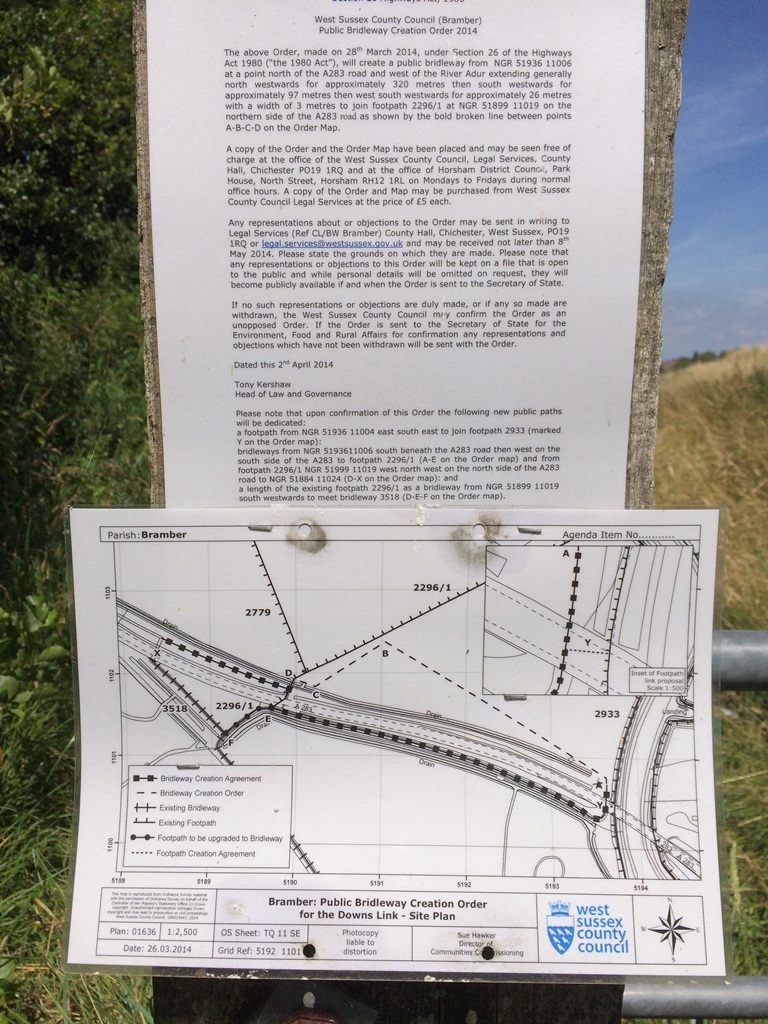
On the western side of the road the route will follow the existing access track(part of which will be the upgraded FP). This runs from the Downs Link alongside the river. At the river the route turns left to pass under the road bridge where it will turn diagonally left to follow a new path within the field which will rejoin the Downs Link bridleway just south of the road crossing.

On 17th July 2014 WSCC said that surfacing works are proposed to happen ‘in the next month or so’ and that clearance work north and south of the road is due to take place on 4th August. The Downslink to the northwest will also be subject to some vegetation cutback. They estimate that the route should be available to use about 3 or 4 weeks from when the works start.FP to be upgraded


Posted in News | Leave a comment

Egrets Way – Phase 2 Official Opening

HJP photo Egrets Way
EgretsWayOpening
The second phase of the Egrets Way, between Southease and Rodmell, was officially opened on 7th June 2014!
The grand ribbon cutting ceremony was a somewhat damp affair but was well attended by walkers, cyclists and horse riders who all benefit from this new bridleway. It takes users safely off the busy and dangerous C7 to link the Southdowns Way National Trail (bridleway) and the bridleway Rodmell 1.

The path is intended to eventually run alongside the River Ouse from Lewes to Newhaven!
The phase 2 section was funded by Paths for the Community funding and as such had to be available to horse riders. Further phases are expected to be funded by government money with the aim to ‘improve cycling in the South Downs National Park’. As such it is by no mean certain that new path sections will be available to horses and so riders must make their voices heard. A planning application is being considered 10th June at Midhurst and this must be approved before any future plans can be implemented.

Posted in News | Leave a comment

Ditchling Common Permissive Path

Gate at B2112 access

Noticing what’s happening on your bridleways is a huge part of what MSABG is about.

Local Rep, Sue Coote, noticed kissing gates being erected as part of the fencing/grazing initiative on Ditchling Common Country Park. Though large, to accommodate wheelchairs, this was not ideal on a bridleway! At her instigation, bridle gates have now been installed instead.
Adding gates to a path previously easy to ride is not good news for riders, but at least these have been well hung. However, one is within a tricky egress into the fence line – feedback on how this rides would be welcome from those using the path.
The path in question is the permissive bridleway along the western side of the B2112 from the Hope Farm driveway to Folders Lane roundabout. The final stretch of this, on to Folders Lane, is now unrideable however with a kissing gate still in place. The bridleway apparently crosses the road north of the roundabout. If you have in the past ridden the section that connects with Folders Lane, please let us know.

Posted in News | Leave a comment