Egrets Way Update

In 2014 MSABG donated £1,000 toward funding a section (phase 2) of a one-mile path alongside the River Ouse called the Egrets Way, linking Rodmell village (bridleway Rodmell 7) and Southease (the South Downs Way) at the Southease bridge. Other local groups and organisations also made donations. A further £600 was donated by MSABG in February 2022.

The picturesque Egrets Way, Rodmell –  Southease section, before construction of the new multi user path.

The Egrets Way project got underway in 2011 and can be found in our previous post in the MSABG website’s news section (Egrets Way – phase 2 official opening).

Group committee members were hot on the trail making sure that equestrians were included in the past and forthcoming plans making sure that the routes became multi-user paths (Ref: October 2013 Newsletter page 7 & Spring 2021 Newsletter page 6).

One of the first jobs was to identify the route, which meant obtaining landowners and planning consent as well as getting funding for most sections of the path.

The route has been constructed in phases; phase 1 was opened officially in September 2012/13 and phase 2 was officially opened in June 2014. Three more phases of construction comprising five miles of path costing £2 million have now been completed.

The latest development will complete the Lewes to Newhaven part of the Egrets Way and will finally create connectively between the two towns and allows a safe and easily accessible route for people of all mobility to travel between the two towns.

The route of the Egrets Way goes from Newhaven’s Riverside Park and following the course of the River Ouse it travels north to Lewes. It passes close to the villages of Piddinghoe and Southease where it loops inland to link up with the villages of Kingston on to Swanborough and Iford and then to Rodmell. At various different locations it joins up with the South Downs Way (SDW), Bridleways, Permissive Bridleways and Quiet Lanes.

This multi-user path measuring 8.8 km in length is between 2.5 – 3 metres in width and is finished in a gravel dressing. There were about 600 users in 2016 but during last year the number increased to 2,400 showing just how useful it has become.

The distance takes the user on a journey through landscapes that are as archaeologically fascinating as well as captivating. There are sites of special scientific interest, pubs, medieval waterways, working farms, lots of wildlife and not forgetting the little Egret, the namesake of the route.

The surrounding topography is generally flat and has a network of fields divided by ditches with few fences in the landscape. Along the route there are views towards Mount Caburn and Lewes.

There is support for the Egrets Way from the following:

  • The South Downs Society who support a shared user path, a link between Newhaven and Lewes.
  • Mid Sussex Area Bridleways Group said it should be a designated bridleway, equestrians need safe off road access and this path now links it with the South Downs Way.
  • South Downs Local Access Forum support Paths for Communities, a link to Lewes and Newhaven and a path for bridleway users.
  • Cycle Lewes will encourage more cycling within the local area, it would boost tourism and open access to the SDNP.
  • Cycle Seahaven said it opens up the area for the public and gives access for walkers, cyclists, horse riders, families and people of all abilities.
  • Kingston Road and Cranedown Residents Association said the path is a huge success and gives benefits to other communities in the Lower Ouse Valley.

There is an Egrets Way committee which meets every few months which looks after the path e.g. wear and tear, signage, storm damage, and monitoring of users.

Hopefully riders will soon be able to use the last remaining part of the Egrets Way, (phase 6) stretching right into Newhaven, scheduled to be completed in 2022.

A useful map showing the full extent of the Egrets Way and the connecting paths that join up to it, can be accessed by clicking on the following link: https://static1.squarespace.com/static/5ba210db4611a09b277396f5/t/6079676ddadf1639287fc484/1618569072508/Egrets+Way+Overview+EWP+FINAL+draft.pdf

Posted in News | Leave a comment

MSABG help with funding towards new bridleway

MSABG help with funding towards the new bridleway, now recorded as Iford 13 on the definitive map, between Lewes and Iford.

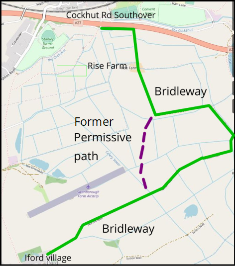
Following negotiations between the Iford Estate and the Ramblers, alongside other access organisations, a new bridleway has been opened between Southover, Lewes and Iford, via Rise Farm. The public notice has now been published.

The route, which runs from the bridge under the Lewes by-pass at Cockshut Road, Lewes across the levels to Iford, is a new route for equestrians, cyclists and walkers.  It is part of the growing network of routes for non-powered users south of Lewes and fills a large gap in the rights of way network locally.

The application was submitted by Chris Smith, representing the Ramblers Association (RA) as part of a national campaign to find ‘lost’ byways where there is sufficient documented historical evidence of their existence and past use, so that they can become legally established Right of Ways.

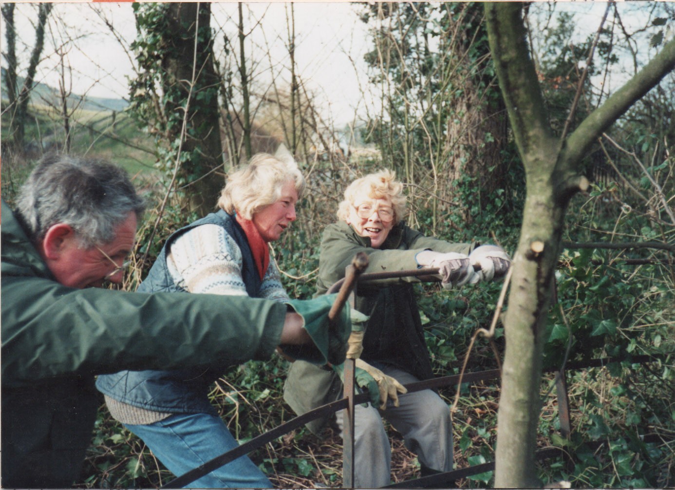
However, funding for the necessary fences and gates to protect livestock was necessary.

This is where MSABG contributed £500, the BHS £2,500, Iford Parish £250, Egrets Way £1000 and SDNPA £1,000. This was on the understanding that the new route would become a definitive bridleway.

Since the previous donations it became apparent that there was a shortfall of £1,961; the SDNPA (South Downs National Park Association) has confirmed £1000 leaving just under £1000 to find – £200 per organisation. The SDNPA will also be funding the cost of new signage for the route and installing it (c £600). It was confirmed that all the gates and fixings are up to BHS standards.

The BHS has offered an extra £200 and the MSABG committee have also agreed to donate an extra £200 as well, making our contribution £700 in total.

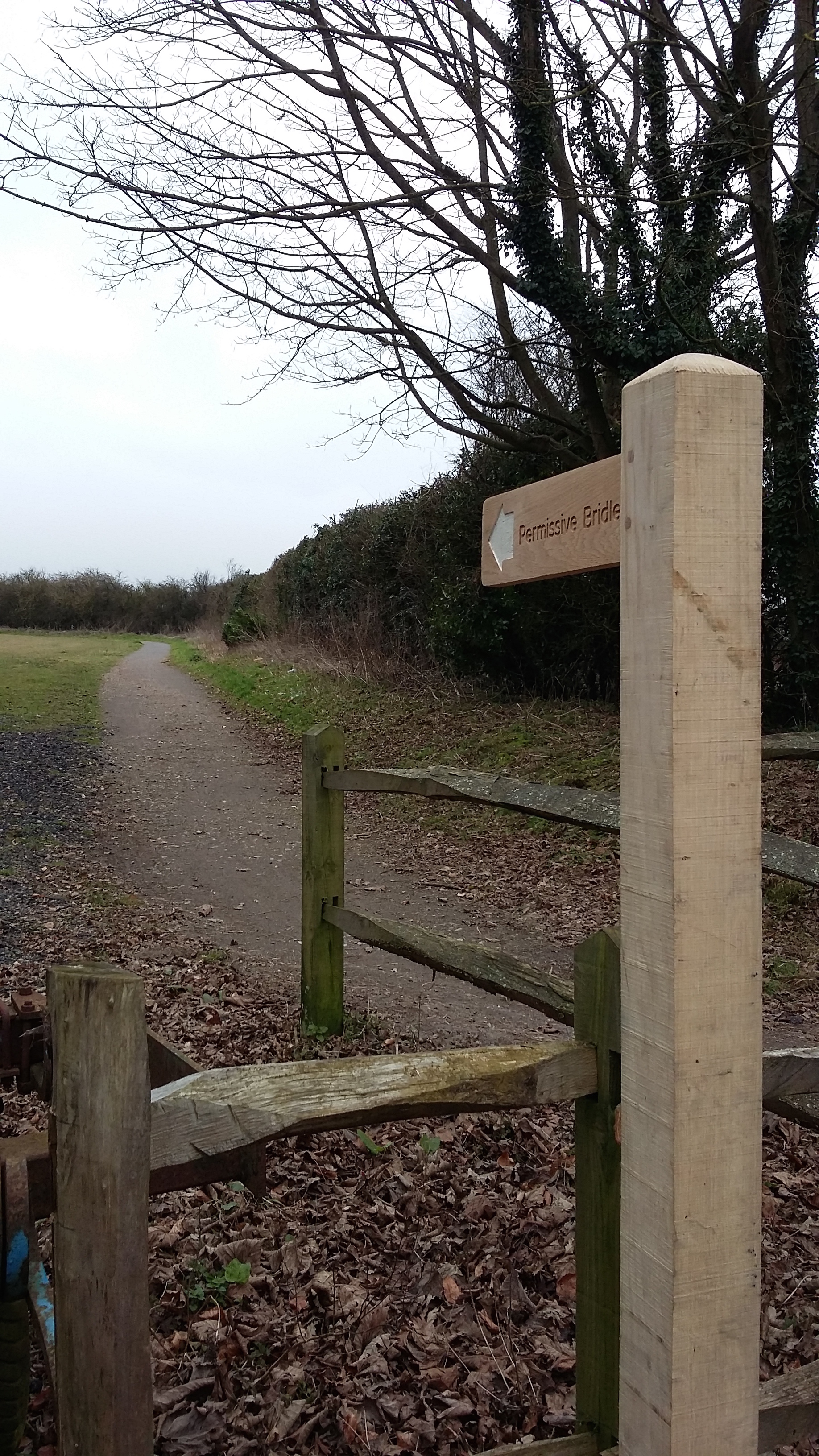
The bridleway is now legally available for use, despite the celebratory opening being cancelled, with all gates and fencing now in place. It has been confirmed that all gates are up to BHS standard.


See map below of the new bridleway and the former permissive route to be removed.

Posted in News | Leave a comment

Barcombe Mills Appeal

Barcombe Mills Bridleway claim update.   

Back in 2017 a claim was made to put the Old Toll Road at Barcombe Mills onto the Definitive Map. It was then learned that the adjoining Hayes Lane, although shown on the East Sussex County Council’s internet Definitive Map as a right of way, was not on the paper version which is the legal document.

The route is also shown on Ordnance Survey maps as part of the Sussex Ouse Valley Way but, in fact, it was not a public highway of any kind. So a claim for both was made in May 2018.

There followed a number of objections from and responses to the owner of Barcombe House and the Ouse Angling Preservation Society. When no Order had been made by ESCC by May 2019 I took the matter to the Planning Inspectorate.

In September 2019 the Inspectorate informed me that ESCC were to be allowed a further 12 months to consider the situation. So in September 2020 I telephoned ESCC to ask why they had not made an Order and was told that it was delayed because of covid!

Mary Parker – MSABG Chairperson.

Posted in News | Leave a comment

BHS New Free – Report an Incident – Phone App.

The free of charge new app, ‘Horse i’, has been specifically designed to empower equestrians to immediately report any incidents they encounter directly to the BHS via a simple, easy-to-use interface.

https://play.google.com/store/apps/details?id=com.BHS.Horsei&hl=en_GB&gl=US

An incident report can be submitted via the time-saving new tool in less than three minutes, although there is also the facility for the user to take the time to add in any supporting detail if they wish. The app records details of the incident, including the location, date and time, any injuries sustained, vet treatment required, as well as if any other agencies are involved, such as the Police or Civil Aviation Authority.

Please read our Safety section for information on reporting incidents.

Posted in News | Leave a comment

Lesley’s Path

 The History of Lesley’s Path.

Originally the land now occupied by Lesley’s path was once fenced and occupied by two small ponies. It’s believed that the land was and probably still is owned by East Sussex County Council.

During the late 1980s Lesley Cook, one of our founder members, became more and more concerned about the large number of people riding along the B2116 with an ever increasing amount of traffic.  In 1990 Lesley suggested that MSABG should take over the paddock and open it up as a public path. A couple of clearances soon created a path and it started to be used. In May 1993 Lesley wrote in our Newsletter:

“the strip of land from Novington Lane to Odintune Lodge is officially ours to manage.”

A last-minute hitch occurred when gypsies encamped there but they were soon gone.

MSABG were pleased to announce that following support from users of Lesley’s Path (from the top of Novington Lane/adjacent to Lewes Road B2116), East Sussex County Council’s Rights of Way Team report that the bridleway was formally created on 2nd February 2018 and is officially known as ‘East Chiltington Public Bridleway 48’.

The RoW Team installed the public bridleway posts at either end of the bridleway and also re-attached the ‘Lesley Cook’ plaque to one of the posts dedicated to her memory.

See below a link for a write up by Reporter Jennifer Logan of the Mid Sussex Times newspaper 22.2.2018.

https://www.midsussextimes.co.uk/news/video-mid-sussex-bridleway-in-memory-of-lesley-given-status-1-8396403


Leslie Cook, Sheila McCormick and her husband getting to grips with a broken iron fence.

Posted in News | Leave a comment

Permissive Bridleway Falmer-Woodingdean

Because of poor signage the equestrian use of this BW has been questioned by other users.

Through the multi-year efforts of Chris Smith the path has not only been cleared of encroaching vegetation but is now FINALLY SIGNED PROPERLY

In mid February 2017 two new permissive bridleway signs were installed by the team at Stanmer Park; one at either end of the route. 
SDNPA say that they  “hope that the addition of this signage will put an end to any doubts over permission for horse riders to use it.  …… the path itself is not the responsibility of the National Park Authority and the issue of its adoption as a bridleway by ESCC remains outstanding.

A brief history of the Falmer- Woodingdean path

Some years ago ESCC held a consultation on the spending of cycle funding paid under the Sustainable Communities Fund.  It was decided to use part of this money to create a bridleway parallel to the road between Woodingdean and Falmer- or so the consultation claimed.  The way was to be used by pedestrians, equestrians and cyclists. The national park is the lead co-ordinator for this route.

The north part of this route replaced a permissive bridleway which was an important link between bridleways south of the A27 and those to the north.  There are, of course few crossings of the A27 suitable for equestrians.  However equestrian interests did not object to the removal of this permissive route because a longer route with statutory rights was being created. However this did not happen!  

Instead signs were erected showing the route as being accessible only to pedestrians and cyclists. As a result of this horse riders were subject to abuse and complaints from cyclists when taking horses down the route. For a short period after the route opened it was wished to keep horses off of the route until it had settled.  However after this period was long gone the signage still showed walker and a cyclist silhouettes only.

ESCC would not initially take on responsibility for the route because it had been built to such a poor standard, but subsequently  felt that the path was in a state where it would not be damaged by equestrian use and that there was no reason why it should not be opened to equestrians.  They said they would arrange this – but didn’t!  

  Chris pursued the SDNPA as equestrians were being deterred from using an important route that they had used for many years due to the actions and inaction of the National Park.

He pressed that the park ensure that signs welcoming equestrians were put in place at the start and finish of the route and at junctions with bridleways. The start and end signs are at last in place.

BUT: We all should press that full statutory bridleway status be granted for this BW to preserve it in perpetuity.

Posted in News | Leave a comment

Cycling and Walking Strategy in England.. please read

Posted in Uncategorized | Leave a comment

Lewes 52 – a new bridleway designated

Lewes 52 – a new bridleway

The new BW is on a route that was the first official cycle route in Lewes, from the Stanley Turner Sports Ground, Kingston to Southover High Street. It is on land alongside the A27, residue from when the “new” A27 was built.

Although in the past it was fairly well used by horse riders coming from the south and east of Lewes to the South Downs, it is not much ridden at the moment.

In 2014 the Kingston Road Residents Association had sought agreement from ESCC to designate it as a bridleway, principally to enable gates to be erected to stop use by traffic.

The status of the route was undetermined and, as well as small amount of local use for access, was now being used by heavy vehicles from Rise Farm at which there are several industrial units. Attempts to gate the route had failed as the gates were vandalised. ESCC started the process of dedication.

The farm then made an application (Feb 2015) to legalise their use of the lane to avoid a lengthier road route (removal of a condition of the original approval for farm diversification which precluded them using this route!).

There were a huge number of objections as the route was much used for leisure purposes, was narrow and there would be no way of preventing other vehicles from using it. It would easily become a rat run.

MSABG also submitted an objection. The adjoining bridleway Lewes 3 was to be part of the route applied for by the farm Also it links the roadside path along Kingston Road with the Egrets Way section that will run alongside the River Ouse, both of which, if landowner objections could be overcome, would be great to ride.

The application was refused on safety grounds and that it contravened 5 local plan policies and National Planning Policy Framework provisions.

On 4th Nov ESCC recorded the cycle route as bridleway Lewes 52. BW status stops at the water works but we are assured that the final stretch from here to Kingston Road is adopted and thus already has public access. The on-line map does not however show it as such.

Posted in News | Leave a comment

Don’t Lose Your Way

2026 might seem light years away but the process for recording a bridleway has been know to take as long as 13 years!
Your help NOW could make all the difference as you will see from the attached MSABG Bulletin Don’t lose your way
Please feel free to forward this email onto other riders/bridleway users who may be interested in this bulletin.

Posted in News | Leave a comment

Sussex Yeomanry

john 1
Sussex Yeomanry
john 2
badge
HISTORY….HORSES….EDUCATION…. FUN
Mounted Skill at arms/tentpegging – taught and displayed by the master!
Download their information sheet here. It tells you what they are available to do, i.e. give demonstrations, attend corporate events, add a different dimension to educational workshops,                                                                             weddings, etc. and host competitions.
Also see the new Sussex Yeomanry website at                                                                      https://sussexyeomanry.uk/ and find them on                                                                             Facebook and Twitter.

Posted in Wanted | Leave a comment